Software
![]()
RapidLiq is Windows software for predicting liquefaction-induced ground failure using geospatial models, which are particularly suited for regional scale and rapid-response applications.
- RapidLiq v1.0 includes four such models. One is a logistic regression model developed by Rashidian and Baise (2020). The other three are machine and deep-learning models developed by Geyin et al. (2022), who recommended use of their “ensemble” model.
- All necessary predictor variables are compiled in RapidLiq. The only input is a ground motion raster downloadable minutes after an earthquake, or available for enumerable future earthquake scenarios. This gives the software near-real-time capabilities, such that ground failure can be predicted at regional scale within minutes of an event.
- The software outputs geotiff files mapping the probabilities of liquefaction-induced ground failure. These files may be viewed within the software but explored in greater detail using GIS or one of many free geotiff web explorers (e.g., http://app.geotiff.io/).
Download Latest Version | Full Manual

Horizon is Windows software for analyzing the occurrence, consequence, mitigation, and economics of seismically-induced soil liquefaction via CPT sensing and models. Salient features include:
- CPT processing: Inverse filtering and interface correction; CPT sensor alignment via statistical cross-correlation.
- Six triggering models; Four free-field manifestation models; Shallow-foundation fragility and vulnerability models.
- Seamless integration with USGS probabilistic seismic hazard analysis (PSHA) framework; Compute return periods of free-field manifestation, foundation damage, and economic loss.
- Cost-benefit analytics for deciding whether/how to mitigate liquefaction risks; Quantify value of planned or constructed mitigation activities, wherein improvement is detected and incorporated via changes to CPT sensing data.
Download Latest Version | Quick Read-Me | Full Manual | Version History
Map Products
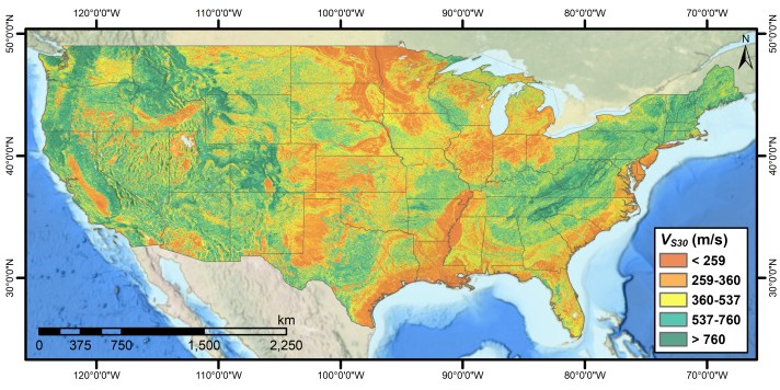
U.S. National VS30 Maps
- Geyin, M. and Maurer, B.W. (2022). “U.S. National Vs30 Maps Informed by Remote Sensing and Machine Learning.” DesignSafe-CI. DesignSafe-CI, doi: 10.17603/ds2-80d8-9m83. (Geotiff Files and Paper)
Datasets
Paleoliquefaction Data
- Rasanen, R.A., Marafi. N., and Maurer, B.W. (2020). “Compilation and Forecasting of Paleoliquefaction Evidence for the Strength of Ground Motions in the U.S. Pacific Northwest: A Digital Dataset (Version 1).” DesignSafe-CI, doi: 10.17603/ds2-jm19-2w09. (Dataset and ReadMe)
Liquefaction Case-History Data
- Rasanen, R.A., Geyin, M. and Maurer, B.W. (2022). “Select CPT-Based Liquefaction Case Histories from the 2001 Nisqually, Washington, Earthquake (Version 1).” DesignSafe-CI. DesignSafe-CI, doi: 10.17603/ds2-nsf8-7944. (Dataset and ReadMe)
- Geyin, M. and Maurer, B.W. (2021). “CPT-Based Liquefaction Case Histories from Global Earthquakes: A Digital Dataset (Version 1).” DesignSafe-CI. DesignSafe-CI, doi: 10.17603/ds2-wftt-mv37. (Dataset and ReadMe)
- Geyin, M., Maurer, B.W., Bradley, B.A., Green, R.A., and van Ballegooy, S. (2020). “CPT-Based Liquefaction Case Histories Resulting from the 2010-2016 Canterbury, New Zealand, Earthquakes: A Curated Digital Dataset (Version 2).” DesignSafe-CI, doi: 10.17603/ds2-tygh-ht91. (Dataset and ReadMe)
